
Marketing a large-scale housing development presents a unique challenge. Individual property renders show buyers what a single home looks like, but they cannot communicate the scope, layout, and setting of an entire scheme. For developments of fifty, a hundred, or several hundred homes, buyers and investors need to understand the full picture, including the road layout, the green spaces, the relationship between plots, and how the development sits within its wider surroundings. Aerial CGI delivers exactly that perspective.
At iCreate, we produce photorealistic aerial visualisations that give developers a powerful tool for marketing large residential schemes before a single foundation is laid. These bird’s-eye renders transform flat masterplan drawings into vivid, three-dimensional images that buyers, investors, and planning committees can understand at a glance. In this guide, we explore how aerial CGI supports every stage of property marketing for large-scale housing developments.
When a development spans dozens or hundreds of plots, the standard marketing toolkit of street-level exterior renders and interior CGI is not enough on its own. Buyers considering a home within a larger scheme want to know where their plot sits relative to open space, parking, access roads, and neighbouring properties. Investors and development finance providers need to see the full masterplan brought to life before they commit capital. Aerial CGI answers all of these questions in a single, immediately understandable image.
An aerial render shows the entire development from an elevated viewpoint, revealing the layout of streets, the distribution of house types, landscaping, play areas, and infrastructure. Unlike a flat site plan, an aerial CGI places the scheme in its real-world context. Surrounding roads, existing buildings, countryside, or coastline are all visible, giving viewers a true sense of place. This context is invaluable for marketing because it addresses one of the most common buyer concerns: what will it actually be like to live here?
For developers, aerial CGI also serves as a strategic communication tool. It demonstrates to stakeholders that the scheme has been carefully planned, that green space has been thoughtfully integrated, and that the development respects the character of its surroundings. This level of visual clarity builds confidence across every audience, from first-time buyers to institutional investors.

Send us your site layout, masterplan drawings, and any aerial photography or OS mapping of the surrounding area. We review the scheme and agree the best viewpoints, elevation, and scope for your aerial CGI package.
Our team builds the full development in 3D from your drawings, adds accurate landscaping, road infrastructure, and surrounding context, then renders each aerial scene to photorealistic quality. You receive draft views for review.
We share draft aerial renders for your feedback, make any adjustments to viewpoints or details, and deliver final high-resolution images ready for brochures, hoardings, websites, and investor presentations.
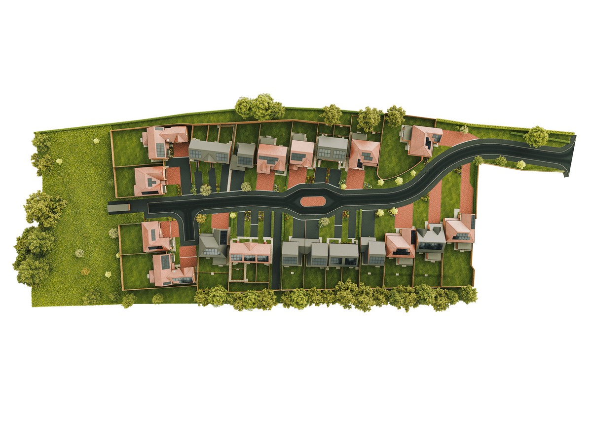
Aerial CGI supports every stakeholder involved in the planning, funding, and marketing of large-scale housing developments. From the developer pitching to investors to the estate agent guiding buyers through an off-plan sales launch, bird’s-eye visualisations provide the context and clarity that other marketing assets cannot match.
At iCreate, we have over twenty years of experience producing aerial CGI for residential developments of all sizes. Whether you are marketing a boutique scheme of thirty homes or a multi-phase masterplan of several hundred, our team delivers visualisation packages that help you sell faster and present with confidence.
The buying decision for a home within a large development is rarely based on the property alone. Buyers want to understand the lifestyle the development offers, such as the proximity to green space, the quality of the streetscape, the sense of community that the layout creates. Aerial CGI communicates all of this in a way that brochure copy and street-level images simply cannot. A single bird’s-eye render can show the entire scheme in context, giving buyers the confidence to reserve off-plan before construction is complete.
For investors and development finance providers, aerial visualisations serve a different but equally important purpose. They demonstrate the scale of the opportunity, the quality of the masterplanning, and the developer’s attention to detail. When we produce aerial CGI at iCreate, we include accurate landscaping, road markings, boundary treatments, and even vehicle and pedestrian activity to bring the scene to life. The result is an image that looks like a photograph taken from a drone above the completed development, a compelling asset for investor presentations and funding applications.
We have seen developers use our aerial renders across sales brochures, hoarding panels, website hero banners, and social media campaigns. The versatility of a high-quality aerial CGI means it delivers value across every marketing channel, making it one of the most cost-effective assets in a developer’s CGI marketing package.

Aerial CGI is not only a marketing tool. It also plays a critical role in the planning process for large-scale housing developments. Planning officers, committee members, and local residents often struggle to interpret technical site plans and elevational drawings. An aerial visualisation translates these documents into something everyone can understand, showing how the proposed development will look and feel once built.
For schemes that face local scrutiny, aerial CGI can be particularly persuasive. It demonstrates that the developer has considered the relationship between the new homes and existing properties, that green corridors and open spaces have been meaningfully incorporated, and that the scale of the development is appropriate for its setting. At iCreate, we work closely with developers and their planning consultants to produce aerial views from angles that best communicate the scheme’s merits, including verified viewpoints that match real-world camera positions for accuracy.
Beyond planning submissions, the same aerial CGI assets are invaluable for public consultations and community engagement. Displaying a photorealistic aerial view at a consultation event gives local residents a clear picture of what is being proposed, reducing misunderstanding and building support. Developers who invest in quality architectural visualisation for their planning strategy consistently report smoother approval processes and fewer objections.

Aerial visualisation offers a range of benefits that extend well beyond a striking image. Here are six ways aerial CGI strengthens the marketing, planning, and sales process for large-scale residential schemes:
Aerial CGI shows the entire scheme in one image, capturing road layout, plot distribution, green spaces, and surrounding context. Buyers and investors understand the development instantly without interpreting technical plans.
Buyers commit faster when they can see where their plot sits within the wider development. Aerial renders give off-plan purchasers the confidence to reserve before construction begins, reducing sales timelines.
Planning officers and committee members assess proposals more favourably when they can visualise the development in context. Aerial CGI demonstrates thoughtful masterplanning and reduces the risk of objections.
Investors need to see the scale and quality of a scheme before committing capital. A photorealistic aerial render communicates professionalism and gives funders confidence in the developer’s vision.
The same aerial CGI can be used across brochures, hoarding panels, website banners, social media campaigns, and investor decks, maximising the return on a single visualisation investment.
Displaying aerial visualisations at public consultations helps local residents understand the proposal clearly, reducing misunderstanding and building community support for the development.
Aerial CGI is one of the most effective tools available to developers marketing large-scale housing schemes. It communicates scale, context, and quality in a single image, giving buyers the confidence to commit off-plan and giving investors the visual evidence they need to back the project. When combined with street-level exterior renders, interior CGI, and animated flythroughs, aerial visualisation completes the picture and ensures every audience sees the development at its best.
If you are planning a large residential development and need aerial CGI that does justice to the scale and ambition of your scheme, our team at iCreate is here to help. We work with developers across the UK to produce photorealistic aerial visualisations that support planning, attract investment, and drive off-plan sales from the earliest marketing stages.
To see examples of our aerial CGI work, request a free sample from our team. We will show you how bird’s-eye visualisation can transform the way you market your next large-scale development.

Aerial CGI is a photorealistic bird’s-eye visualisation of a development created from architectural drawings and site data. It shows the full scheme from an elevated viewpoint, including roads, landscaping, housing layout, and surrounding context. Developers use it for marketing, planning submissions, and investor presentations.
Professional aerial CGI is virtually indistinguishable from drone photography. Our renders at iCreate include accurate materials, landscaping, road markings, vehicles, and surrounding buildings to create images that look like photographs of the completed development taken from above.
Yes. Aerial visualisations help planning officers and committee members understand the scale and context of a proposed development far more effectively than technical site plans. They demonstrate how the scheme relates to its surroundings, which supports a more favourable assessment of the application.
We typically need the site layout or masterplan, house type elevations and floor plans, landscape proposals, and any aerial photography or mapping of the surrounding area. The more detail provided, the more accurate and compelling the final aerial render will be.
Timelines depend on the scale and complexity of the scheme. A single aerial view of a medium-sized development typically takes ten to fifteen working days. Larger masterplans with multiple viewpoints may take three to four weeks. We confirm timelines at the briefing stage.
Absolutely. Aerial renders work best as part of a complete visualisation package that includes street-level exterior CGI, interior renders, and animated flythroughs. Together, these assets give buyers a comprehensive view of the development from every perspective.
Very much so. A single aerial CGI can be used across brochures, hoardings, websites, social media, and investor presentations, making it one of the most versatile and cost-effective assets in a property marketing package. The investment is modest relative to the sales revenue it helps generate.
Yes. We can produce aerial visualisations that highlight individual phases of a multi-phase development, showing which plots are available, which are under construction, and which are complete. This is particularly useful for phased sales launches and investor updates.
Sing up for our newsletter

